article_detail
  • CONTACT
  • ADVERTISE WITH US
  • WEEKLY BULLETIN
  • Region
  • Águilas
  • Alhama de Murcia
  • Jumilla
  • Lorca
  • Los Alcázares
  • Mazarrón
  • San Javier
  • ALL AREAS & TOWNS
    • AREAS
    • SOUTH WEST
    • MAR MENOR
    • MURCIA CITY & CENTRAL
    • NORTH & NORTH WEST
    • TOWNS
    • Abanilla
    • Abarán
    • Aguilas
    • Alamillo
    • Alcantarilla
    • Aledo
    • Alhama de Murcia
    • Archena
    • Balsicas
    • Blanca
    • Bolnuevo
    • Bullas
    • Cañadas del Romero
    • Cabo de Palos
    • Calasparra
    • Camping Bolnuevo
    • Campo De Ricote
    • Camposol
    • Canada De La Lena
    • Caravaca de la Cruz
    • Cartagena
    • Cehegin
    • Ceuti
    • Cieza
    • Condado de Alhama
    • Corvera
    • Costa Cálida
    • Cuevas De Almanzora
    • Cuevas de Reyllo
    • El Carmoli
    • El Mojon
    • El Molino (Puerto Lumbreras)
    • El Pareton / Cantareros
    • El Raso
    • El Valle Golf Resort
    • Fortuna
    • Fuente Alamo
    • Hacienda del Alamo Golf Resort
    • Hacienda Riquelme Golf Resort
    • Isla Plana
    • Islas Menores & Mar de Cristal
    • Jumilla
    • La Azohia
    • La Charca
    • La Manga Club
    • La Manga del Mar Menor
    • La Pinilla
    • La Puebla
    • La Torre
    • La Torre Golf Resort
    • La Unión
    • Las Palas
    • Las Ramblas
    • Las Ramblas Golf
    • Las Torres de Cotillas
    • Leiva
    • Librilla
    • Lo Pagan
    • Lo Santiago
    • Lorca
    • Lorquí
    • Los Alcázares
    • Los Balcones
    • Los Belones
    • Los Canovas
    • Los Nietos
    • Los Perez (Tallante)
    • Los Urrutias
    • Los Ventorrillos
    • Mar De Cristal
    • Mar Menor
    • Mar Menor Golf Resort
    • Mazarrón
    • Mazarrón Country Club
    • Molina de Segura
    • Moratalla
    • Mula
    • Murcia City
    • Murcia Property
    • Pareton
    • Peraleja Golf Resort
    • Perin
    • Pilar de la Horadada
    • Pinar de Campoverde
    • Pinoso
    • Playa Honda
    • Playa Honda / Playa Paraíso
    • Pliego
    • Portmán
    • Pozo Estrecho
    • Puerto de Mazarrón
    • Puerto Lumbreras
    • Puntas De Calnegre
    • Region of Murcia
    • Ricote
    • Roda Golf Resort
    • Roldan
    • Roldan and Lo Ferro
    • San Javier
    • San Pedro del Pinatar
    • Santiago de la Ribera
    • Sierra Espuña
    • Sucina
    • Tallante
    • Terrazas de la Torre Golf Resort
    • Torre Pacheco
    • Totana
    • What's On Weekly Bulletin
    • Yecla


  • Home
  • Areas
    • SOUTH WEST
    • MAR MENOR
    • MURCIA CITY & CENTRAL
    • NORTH & NORTH WEST
  • Towns
    • Abanilla
    • Abarán
    • Aguilas
    • Alamillo
    • Alcantarilla
    • Aledo
    • Alhama de Murcia
    • Archena
    • Balsicas
    • Blanca
    • Bolnuevo
    • Bullas
    • Cañadas del Romero
    • Cabo de Palos
    • Calasparra
    • Camping Bolnuevo
    • Campo De Ricote
    • Camposol
    • Canada De La Lena
    • Caravaca de la Cruz
    • Cartagena
    • Cehegin
    • Ceuti
    • Cieza
    • Condado de Alhama
    • Corvera
    • Costa Cálida
    • Cuevas De Almanzora
    • Cuevas de Reyllo
    • El Carmoli
    • El Mojon
    • El Molino (Puerto Lumbreras)
    • El Pareton / Cantareros
    • El Raso
    • El Valle Golf Resort
    • Fortuna
    • Fuente Alamo
    • Hacienda del Alamo Golf Resort
    • Hacienda Riquelme Golf Resort
    • Isla Plana
    • Islas Menores & Mar de Cristal
    • Jumilla
    • La Azohia
    • La Charca
    • La Manga Club
    • La Manga del Mar Menor
    • La Pinilla
    • La Puebla
    • La Torre
    • La Torre Golf Resort
    • La Unión
    • Las Palas
    • Las Ramblas
    • Las Ramblas Golf
    • Las Torres de Cotillas
    • Leiva
    • Librilla
    • Lo Pagan
    • Lo Santiago
    • Lorca
    • Lorquí
    • Los Alcázares
    • Los Balcones
    • Los Belones
    • Los Canovas
    • Los Nietos
    • Los Perez (Tallante)
    • Los Urrutias
    • Los Ventorrillos
    • Mar De Cristal
    • Mar Menor
    • Mar Menor Golf Resort
    • Mazarrón
    • Mazarrón Country Club
    • Molina de Segura
    • Moratalla
    • Mula
    • Murcia City
    • Murcia Property
    • Pareton
    • Peraleja Golf Resort
    • Perin
    • Pilar de la Horadada
    • Pinar de Campoverde
    • Pinoso
    • Playa Honda
    • Playa Honda / Playa Paraíso
    • Pliego
    • Portmán
    • Pozo Estrecho
    • Puerto de Mazarrón
    • Puerto Lumbreras
    • Puntas De Calnegre
    • Region of Murcia
    • Ricote
    • Roda Golf Resort
    • Roldan
    • Roldan and Lo Ferro
    • San Javier
    • San Pedro del Pinatar
    • Santiago de la Ribera
    • Sierra Espuña
    • Sucina
    • Tallante
    • Terrazas de la Torre Golf Resort
    • Torre Pacheco
    • Totana
    • What's On Weekly Bulletin
    • Yecla
  • Murcia News
  • Weather &
    Climate Change
  • What's On &
    Where To Go
    • What's On
    • Where To Go
    • Daily Events Diary
  • Motoring
    & Travel
    • All Motoring & Travel News
    • Driving In Spain
    • Spanish Motoring Laws
  • Lifestyle
    • Murcia LifeStyle
    • Sporting & Leisure
    • Murcia LifeStyle
    • Sporting & Leisure
    • Tips for Expats
    • Murcia Community
    • Tips for Expats
    • Murcia Community
  • Property News
    • Murcia Property News
    • All Murcia Property
    • Murcia Property Sales
    • Murcia Property Rentals
    • Legal & Financial
    • Murcia Property News
    • All Murcia Property
    • Murcia Property Sales
    • Murcia Property Rentals
    • Legal & Financial
  • Spanish News
  • EDITIONS: Spanish News Today Alicante Today Andalucia Today
article_detail

Water, the Rambla de Nogalte and the Fuente del Caño in Puerto Lumbreras


Water, the Rambla de Nogalte and the Fuente del Caño in Puerto Lumbreras

Puerto Lumbreras and its love-hate relationship with the Rambla de Nogalte

Water: you can’t live without it, and on occasion, as the residents of Puerto Lumbreras are all too aware, it’s difficult to live with it as well.

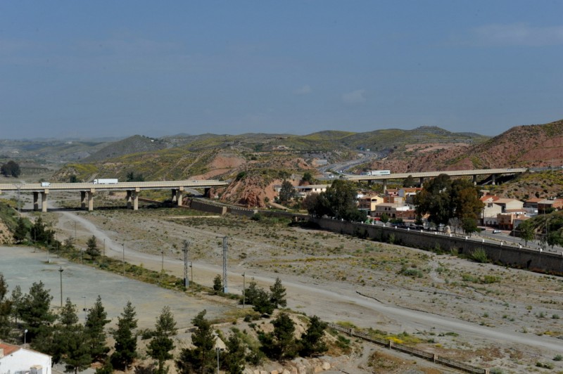
The geography of Puerto Lumbreras is unusual, and often surprises those visiting the town without any prior knowledge, as running through the centre and effectively cutting it in half is a wide “rambla”, or dry river-bed, known as the Rambla de Nogalte. At least, it’s dry for most of the time, and is actually used as a large free car park at almost all times of the year.

But a “rambla” is not just a river which has run dry: it is also a floodwater run-off channel which has been carved into the landscape over the millennia by rainfall cascading down from the higher ground which lies further inland, and when the clouds gather the locals wisely make sure that both they and their cars are out of the rambla.

On 19th October 1973 one of the autumn cloudbursts which are known in this part of Spain as the “gota fría” affected the mountains of which lie to the north and west of Puerto Lumbreras, and although the rainfall was comparatively light in the town itself within a couple of hours the Rambla was full to overflowing as a flash flood made its way towards the Mediterranean coast. The devastation to farmland and the town itself was horrific, the economic losses amounting to millions, but the figure that stands out in the memory is that no fewer than 85 people lost their lives.

A similar episode of torrential rain in October 2012 concluded with 13 deaths in not only Puerto Lumbreras, but also Lorca and Almería, but nonetheless around 150,000 head of livestock were lost.

For this reason, when parking in the Rambla prior to taking a stroll around the town, take a quick look to check that no storm clouds are gathering, and that the locals are not hastily removing their vehicles. The Rambla de Nogalte is a convenient spot to leave the car, but the walls which line it are not merely ornamental: they are containing structures, and although for most of the time it is hard to imagine, the height and volume of the rushing torrent during a gota fría episode can make them seem dangerously fragile structures.

Water, the Rambla de Nogalte and the Fuente del Caño in Puerto Lumbreras

The importance of the Rambla de Nogalte to Puerto Lumbreras

All of this begs the question of how and why the town of Puerto Lumbreras came to occupy such an obviously perilous location, but the answer, to a large extent, also lies in the Rambla de Nogalte.

At first the town came into existence when first Moorish and then Christian forces occupied the castle on top of the hill on the western bank of the  Rambla, and the few  intrepid farmers and other settlers clustered around the fortress for security. But the Moors also discovered that underneath the Rambla de Nogalte just to the north of the town centre was an underground water reserve, and found a way of tapping into it.

Water, the Rambla de Nogalte and the Fuente del Caño in Puerto Lumbreras

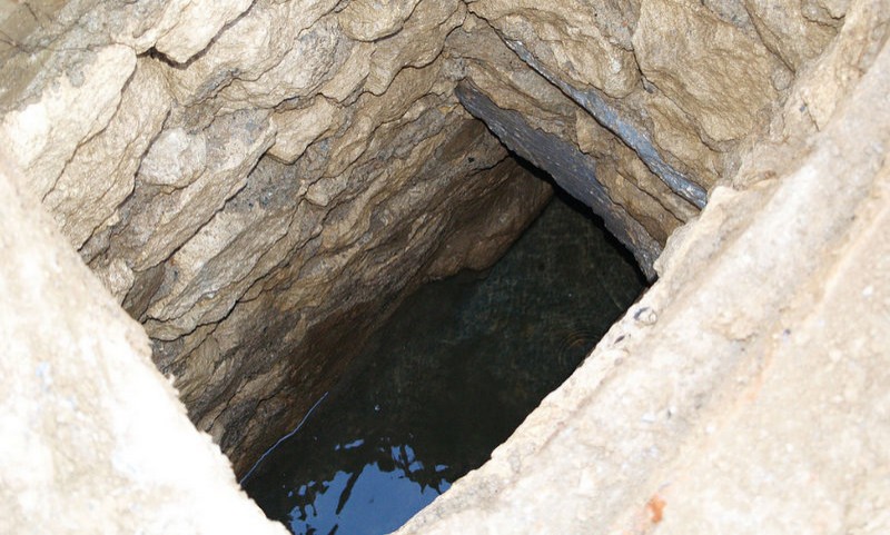
This consisted of the construction of what are still known as the “Cano” and Contracaño”, which are essentially galleries along which the water from this aquifer is channeled. Access to the water is provided by vertical well-like structures which allowed maintenance work to be performed, and these “lamp-holes” are known as “lumbreras”: most accept that this is the origin of the name of the town, such is their importance in its development.

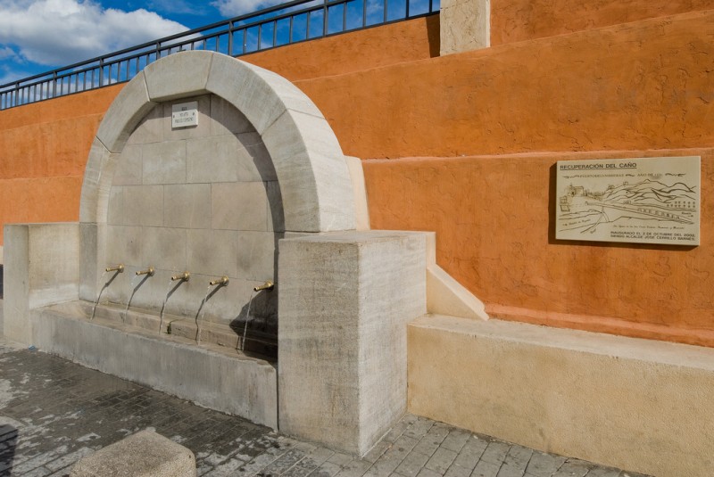
In later years the water was used to supply washhouses, mills, drinking troughs for cattle and of course drinking water for the inhabitants of the town, and the water fountain which stands on the western bank of the Rambla, the Fuente del Caño, is still in operation today. An interesting local by-law was established in 1517, when the owners of pigs were forbidden from allowing their animals to bathe in the water supplied by the Caño on account of the risk to public health.

Water, the Rambla de Nogalte and the Fuente del Caño in Puerto Lumbreras

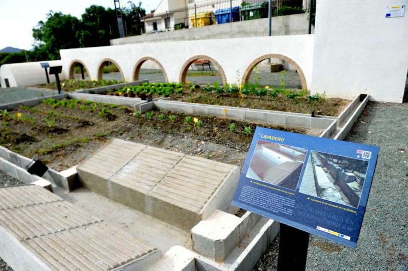
There have been moves to create a “Ruta del Agua” in Puerto Lumbreras which would include not only the fountain but also some of the mills which stand on the eastern bank of the Rambla just downstream of the town centre and the irrigation ditches which supply water to the farmland around the town, but at present the mills are not in sufficiently good condition. The fountain can be seen, though, and at the Casa del Cura there is a fascinating scaled-down recreation of how water is distributed and used in Puerto Lumbreras. 

Further information about the importance of the water network in the municipality can be seen in the cave house complex and castle of Medina Nogalte.

Click for further information about the Puerto Lumbreras municipality


article_detail

article_detail
Contact Murcia Today: Editorial 000 000 000 / Office 000 000 000
Terms And Conditons | Privacy Policy | Legal | About Us | Advertise With Us


To be listed on the CAMPOSOL TODAY MAP please call +34 .
To be listed on the CONDADO TODAY MAP please call +34 .
Guidelines for submitting articles to Camposol Today

Hello, and thank you for choosing CamposolToday.com to publicise your organisation’s info or event.

Camposol Today is a website set up by Murcia Today specifically for residents of the urbanisation in Southwest Murcia, providing news and information on what’s happening in the local area, which is the largest English-speaking expat area in the Region of Murcia.

When submitting text to be included on Camposol Today, please abide by the following guidelines so we can upload your article as swiftly as possible:

Send an email to editor@camposoltoday.com or contact@murciatoday.com

Attach the information in a Word Document or Google Doc

Include all relevant points, including:

Who is the organisation running the event?

Where is it happening?

When?

How much does it cost?

Is it necessary to book beforehand, or can people just show up on the day?

…but try not to exceed 300 words

Also attach a photo to illustrate your article, no more than 100kb